


Mine Mapper 3.0 Beta Version released

Developer Information:
·
Developer Name: Biju Sebastian
·
Previous Positions: Senior Geologist/ Deputy Director (Department
of Mining and Geology, Government of Kerala)
·
Current Address: Kunnamkott House, Manakad PO, Kerala, India, Pin:
685608
·
Developer Email: bsebastian@gmail.com
·
Contact Number: +91 9447310771
·
Feedback Email: theminemapper@gmail.com
·
Website: www.minemapper.in
Re Release date: 17th September 2023
· Key functionalities of Mine Mapper 3.0 include:
·
Effortless KML File Creation: Input precise coordinates of quarry/mine
boundary pillars effortlessly, streamlining the process of generating KML
files.
·
On-Site Location Mapping: Capture real-time location data directly from
your position. This feature is purpose-built for mapping boundary pillars,
including those in sensitive or unauthorized mining areas. Ensuring an
impressive accuracy of around 3 meters, it's a reliable tool for precise
fieldwork.
·
Versatile KML File Types: Create three distinct types of KML
files—polygon, polyline, and point. This versatility empowers geologists to map
various aspects of mining sites, such as boundaries, infrastructure, and
natural features like roads and streams.
·
Layered KML Integration: Superimpose different KML files, allowing for a
comprehensive view of mining operations. This invaluable feature enables
officials to visualize the actual layout of a mine site, facilitating efficient
decision-making.
·
Distance and Area Metrics: Easily calculate the distances between pillars
and the area of the mapped region, providing critical data for planning and
assessment.
·
Field Notes on the Go: Seamlessly record field notes during site
visits, enhancing documentation and analysis capabilities.
·
Geotagged Photo Documentation: Capture geotagged photos with embedded date,
time, and bearing information. This functionality enables geologists to monitor
mining activities over time by comparing images taken from the same vantage point.
·
Efficient File Sharing: Share KML files effortlessly with colleagues
and stakeholders, facilitating collaboration and analysis. Additionally, these
files can be utilized in other compatible applications.
·
Advanced Bearing and Slope Measurements: Determine precise bearings and
slopes without the need for specialized tools, streamlining geological
assessments. This includes the capability to measure strike and dip without a
Brunton compass.
·
Seamless Navigation: Effortlessly navigate to selected points or
markers within the app. This functionality enhances on-site efficiency and
allows for quick access to specific locations without the need to open external
mapping applications.
·
Universal KML/KMZ Compatibility: Import
and open KML or KMZ files created in any application, providing users with the
flexibility to incorporate external data seamlessly into the app.
Mine Mapper 3.0 stands as a significant
advancement in mining management solutions, providing a comprehensive toolkit
finely tuned to meet the precise requirements of professionals engaged in
mineral administration. With its user-friendly interface and a rich array of
features, Mine Mapper 3.0 is positioned to become an indispensable companion
for individuals involved in mining operations, regulation, and geology.
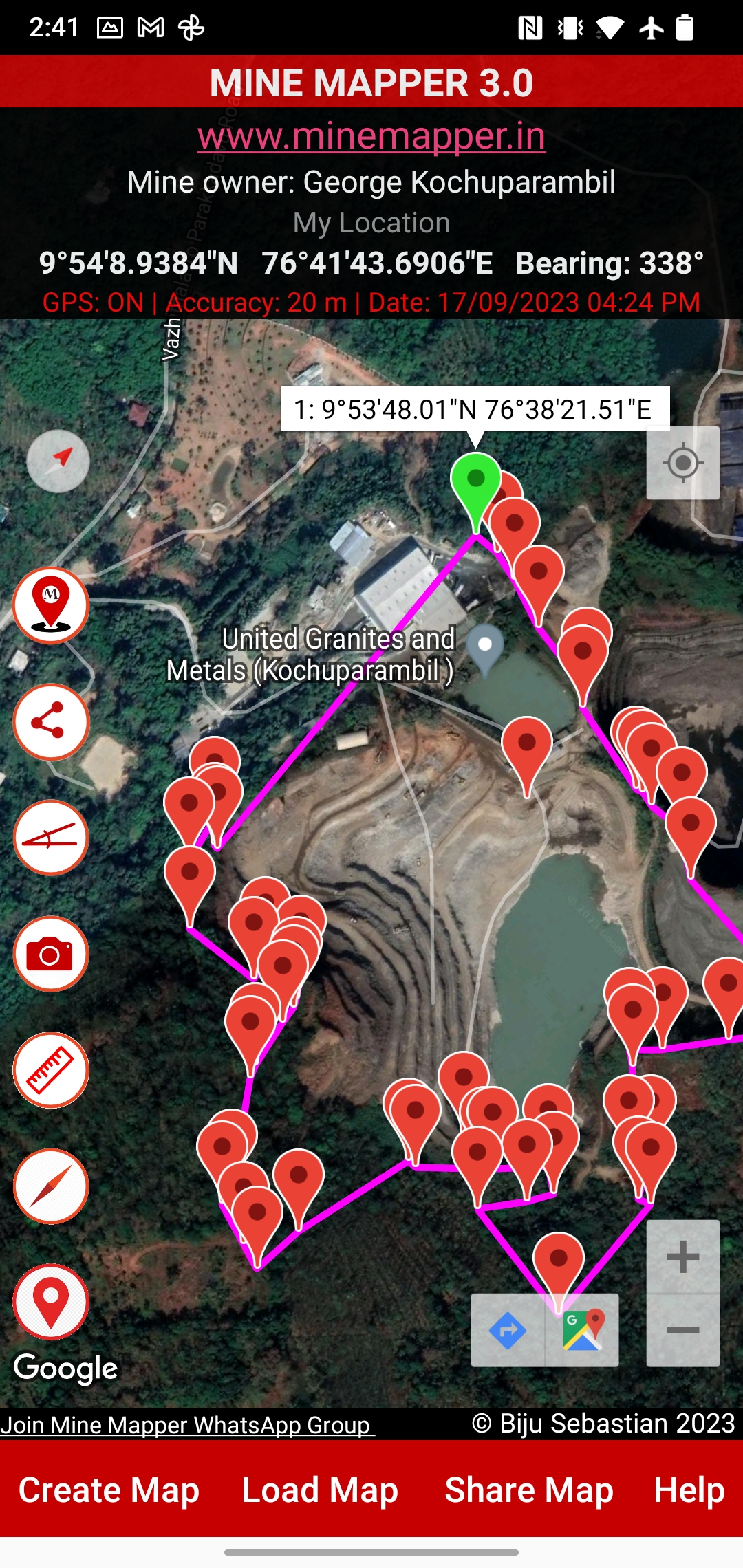
Mine Mapper Functionalities:

Tap this icon to display your
current location (the point where you are standing with the phone).
2. About Mine Mapper:
By tapping this icon, you can access
information about the app developer, release date, and more.

3. Share Loaded KML
File:
Use this icon to share the latest
file loaded in Mine Mapper. Please note that only one file can be shared at a
time by tapping this icon.
4. Show
Slope/Inclination:
Tap this icon to access the
inclinometer. Inclination can be measured by keeping the long side of the
mobile phone on the surface whose slope is to be measured. You can also lay the
phone flat on the surface. The inclination values range from 0 to 90 degrees
based on the tilt. It may be noted hat the angle between the red and black line is slope.

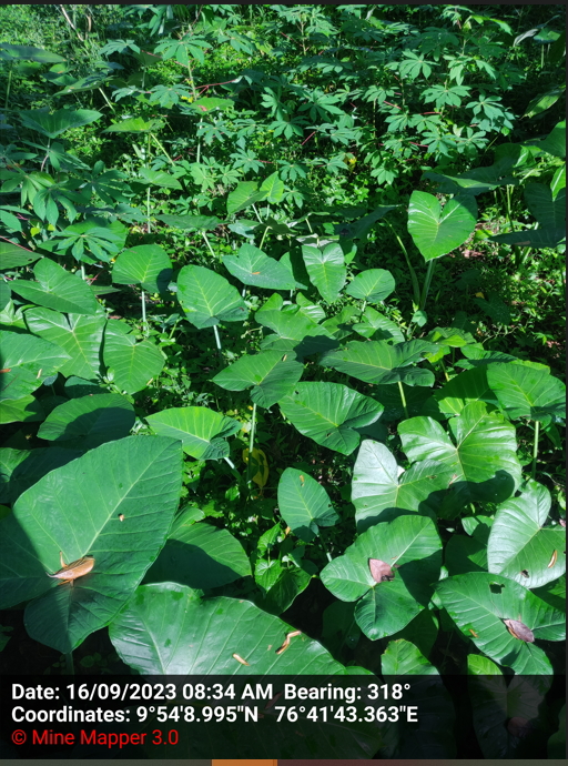
5. Capture Geotagged
Photo with Date, Time, and Bearing:
Tapping this icon will switch to
photo capturing mode. Click the tick mark to save the photo with coordinates,
date, time, and bearing. Please note that as you move in photo capturing mode,
the bearing values will change. Since photos are geotagged, you can retake a
photo of a mine in the same direction from the same point to track changes in
land morphology due to mining. The photo capturing mode also includes a selfie
option.
6. Show Coordinates
and Map Measurements Icon:
Tap this icon to view the
coordinates of points, accuracy, distance between points (pillars), area of the
mine (polygon), and any notes you added during map creation.
7. Show Compass and
Last Known Location:
This icon displays the compass and
your last known location. The last known location is provided in a larger font
size to assist with coordinate readings. Note that during fieldwork, screen
visibility may be affected by sunlight reflection.

8. Show Loaded KML
File:
This icon shows the KML file you
have loaded in the app. Please be aware that the map may not align with your
current location.
9. Join Mine Mapper
WhatsApp Group:
By tapping this option, you can join
the WhatsApp discussion group.
10. Create Map Menu:
Tapping this menu will take you to
the create map page. Here, you have the option to create a KML map in the
following ways:

a) Create Map by
Inputting Points: You can plot a mine using coordinates provided in the mining plan.
Add pillars in a clockwise or counterclockwise manner and save the map by
tapping the "Create Map" button.
b) Create Point Map by Capturing Coordinates: This is useful for capturing the locations of buildings, wells, electric towers, etc. near a mine or applied mine area. Move to the location, add a point, and provide a description.
In case of point map, you will not be able to get the measurements. If you want to know the GPS/Location accuracy double tap on the marker. On first tap you can see the latitude and longitude information in D:M:S format and on second tap you can see the latitude and longitude in Decimal Degrees with Location Accuracy values.
c) Create Line Map by
Capturing Coordinates: This is used for mapping roads or streams near the mine.
d) Create Polygon Map
by Capturing Coordinates: Use this to map a mine boundary or verify the alignment of boundary
pillars. The measurement icon allows you to view boundary pillar coordinates,
distances, area, and any notes.
d) File naming conventions: File names must not contain spaces. You may use underscores ( _ ) instead. Eg: For ABC Iron Ore Mines, file name could be ABC_Iron_Ore_Mines.
11. Load Map Menu:
This menu enables you to load
multiple maps onto the screen. Please note that the measurements icon will
provide measurements for the last loaded map. To remove a loaded map, close and
reopen the app.
12. Share Map Menu:
Use this menu to select multiple
maps and share them with your contacts through WhatsApp, Gmail, Google Drive,
etc. Sharing to Google Drive will serve as a backup for your maps. You can also
use this menu to share photos and screenshots.
13. Navigation:
If you have loaded a KML file
containing locations of mineral depots or mine locations, you can tap any point
you want to visit, and Mine Mapper will open Google Maps for navigation.
14. Latitude and
Longitude, GPS Accuracy, Bearing

On the Home Screen of Mine Mapper,
you'll find the following information:
Latitude and Longitude: This
indicates the precise geographical coordinates of your current location.
GPS Status: This indicates whether
the GPS/location service on your phone is enabled or disabled.
GPS Accuracy: This provides an
estimate of how accurate the GPS signal is at your location.
Date and Time: Displays the current
date and time.
15. Home, Back, Close
Buttons:
No specific buttons/links have been
provided for going back to the previous page or for closing the app, as users
can utilize Android's built-in functionalities. Taking screenshots while using
Mine Mapper can help users capture the Google Earth image available on the
particular date of field work.
16. Using KML Files in
Other Applications:
You can use the KML map created in Mine Mapper in other applications that support KML files, such as Google Earth.
Troubleshooting:
If a saved photo or KML file isn't immediately visible in
the gallery or the Download/Minemapper folder, you may need to adjust the
phone's settings as outlined below:
1. Navigate to Phone Settings.
2. Select Privacy.
3. Choose Permission Manager.
4. Select Files and Media.
5. Locate the Mine Mapper App and set it to "Allowed to
Manage All Files".
After implementing these changes, all files should become
visible immediately.
Important tips:
GPS Accuracy and Waiting Time: Before saving points, ensure the GPS accuracy reaches 3 meters for precise results.
Inclination Values: Please be aware that the inclination measurements may exhibit slight variations depending on the unique capabilities of your mobile phone.
When entering Latitude and Longitude, use the format Degree:Minutes:Seconds. To achieve the highest accuracy, it's advised to provide seconds with four decimal places.
File Saving Location: All files are automatically saved in the folder Download/Mine Mapper.
Accessing Saved Photos: You can conveniently access your saved photos directly from the Gallery.
Copying and Pasting Measurement Data: Simply perform a long press on the measurement data to easily copy and paste it for your convenience.
Editing Pillar Coordinates: When editing a pillar coordinate, please be aware that the displayed data may correspond to the last pillar entered. Input the correct value, and the selected pillar's data will be updated accordingly. This ensures accuracy in your mapping process.
Beta Version: Possible Issues
On certain phones, photos are not being saved correctly.
On other phones, the created KML files may not be
immediately visible and might require manual searching to locate them.
In cases cases, granting permission to access files could potentially resolve the issues mentioned above.
On some phones, the photos taken using the app may not be correctly oriented.
Location Accuracy:
The precision of the coordinates you capture
relies on the capabilities of your phone's GPS receiver. Modern smartphones
typically offer an accuracy of around 3 meters.
WhatsApp Group:
Join the Mine Mapper WhatsApp group for
discussions and to get your doubts clarified. Use the provided link to join and
connect with fellow app users. All the App updates are given through this group.
How to get the Mine Mapper 3.0 App:
To obtain the Mine Mapper 3.0 App please email bsebastian@gmail.com
Please don't forget to mention your name, designation and department.
Disclaimer:
The
Mine Mapper App is provided for preliminary mapping purposes only. While every
effort has been made to ensure accuracy, the developer accepts no
responsibility for inadvertent errors or omissions. The responsibility for the
use of this application and the interpretation of its output lies solely with
the user.

.png)
.png)


.png)
.png)
.png)

0 Comments